Sunday, October 9, 2016

Working your Collection


I have a small collection of fossils I have been gathering in the last 10 years. I have about 100 fossils. So, I just don’t put them in a drawer and forget about them. I study my fossils and gather information to learn more about each specimen and   to make my collection more complete, just like a museum would do.

Some of my fossils are collected by me, by going in the field and getting them after a previews research of each site and some of my fossils are purchased. Purchasing fossils makes lots of sense because that would be the only way you can have a fossils from a faraway locality or collected in an inaccessible place. Museums purchase specimens.

So what do I do with my fossils?

If I have collected the fossils on my own, I need to take geologic maps and Google each location to get the geology of the site. By knowing the geology you also know the Rock formation and the lithology, and if you know that then you will also know the age of the fossil.

If I purchase the fossil then I always need to know three things:

1.      Where does it comes from

2.      What is the geologic formation of the site and

3.      What is the scientific name of the specimen.

Each fossil is numbered by painting a white square on the rock and a number in indelible ink. I also have a data base in excel where I record each specimen with its number and all the information I can get.

Some of that information is the common name of the organisms, the scientific name, location where it comes from, Geologic era, epoch and period and in addition the formation and any other information I can get from the seller, maps, my books or the web.

I also carry a journal where all my fossils are introduced. Each fossil is listed separately, and all kinds of pertinent information is written on the pages. That includes maps, pictures of the specimen, drawing I make and anything else I find.

I spend time taking pictures of my fossils and making drawings of details. I like to research what other organism were living with my specimen and the ecology and biology of the site. You would be surprised of how much paleontology and biology I learn from these fossils.

Recently I purchased a small fish, Dastilbe spp. at the Springfield Rock and Mineral Show. This show happens once a year and I have purchased many of my fossils there. The fossil came with a tag that game me information of the Formation and the age of the specimen. (Cretaceous age and from the Santana Formation in Brazil).

First thing I did is I gave the fossil a number, # 37, and enter the information on my data base in my computer. That is very important because if the tag separates from the rock then you will be in trouble but if the specimen has a number and the data base identify that specimen then you can never lose the information.

Next I Googled for information on the Santana Formation and learn many things that I added to my Journal. I read one scientific paper written by Samuel Davis and Davis Martill were according to the information this small fish appears on both sides of the Atlantic Ocean, in Western Africa and in Brazil, just where the rift between the two continents happed years ago with the help of Plate Tectonics.

So at the end I had a small prize on this fish as is not just a specimen but a result of the separation of continents during Godwana. I now have a story to tell!

I have added two pictures, one of my Fossil Natural History Journal with the information and one of the fish. So next time you start to collect fossil maybe you can add lots of fun to your collection.


Tuesday, January 12, 2016

Another Mystery


This is not my first mystery and would not be the last. That’s why I love science!

On 8/21/12 I went to Whitman Camp to do a program with a group of kids. We went to Billing Lake and collected macroinvertebrates. Always looking for those elusive crustaceans, I kept all I could find. I recently went over my collection and rebelled a population of amphipods, Hyallela azteca . But with the amphipods I found a true shrimp. This small and young shrimp is not completely developed and is difficult to identify as not all the parts are there, but I believe that it is a Grass Shrimp, or Palaemonetes spp.

Lake Billings is a fresh body water, Far from any brakeage or saline environment. I took some chemistry readings that day. There was a Dissolved Oxygen of 7.5 ppm, at a temperature of 25.3 degrees centigrade, a pH of 7.6 and an alkalinity of 80 ppm. which is high for that area but by no means saline. So what was a grass shrimp doing there?

Hyallela azteca is found in fresh water. I also saw some snails, Pseudosaccinea colunella, and some Helisoma spp, all fresh water organisms. This site is at least 7 miles from any salt water.

Here are some pictures of this grass shrimp and also a map.

Coordinates for this collection were 41.50938 Latitude and -71. 87062 longitudes.


Monday, December 7, 2015

Fossil Hunting with your Grandchildren


I have always loved fossils. There is something mystical about touching things that you know were here millions of years ago. So, as part of our vacation I scoped sites nearby where we were going where we could go fossil hunting. Sometimes these areas are private property and you need permission to enter the area, but lucky for us we visited an area that was not restricted.

I sometimes rent a house at Cobscook Bay in Maine. This is passed Arcadia National Park near Lubec. Here the area is still what Arcadia must have been years ago, very primitive, very few tourists and really wonderful places to visit and enjoy. One of the places we visited was what they call Reversing Falls.

Cobscook Bay is part of the Bay of Fundy, the very beginning of it, and the tides are enormous. So there is a site that the fall of the tide makes the waters reverse into a stream and that area is called Reversing Falls.

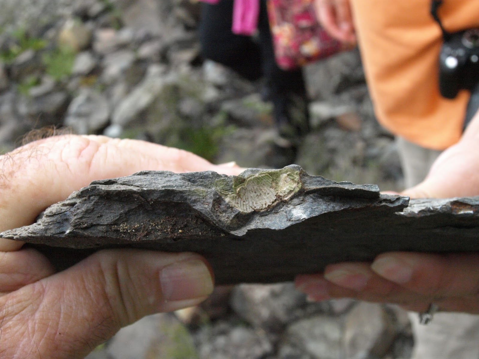
The area is Silurian in age and along the beach there is a cut that if looked carefully you will find Fossils. We came at about 10:00 am. during low tide and work the rock during the morning. The kid loved it. There is nothing like finding your own specimens.

Samples were collected by me, my son and my grandkids at this coastal site. This is part of the Edmnund Formation which s is a fossiliferous area forms by muddy marine sediments. This area is Silurian and Devonian in age, with some volcanic activity at the same time. Edmund Formation Tuff-breccia of Whiting Bay is a resistant rock type. Bring good hammer. Age at about 419 to 424 Million years Old.

We found several fossils: Orthocone is a straight shell Nautiloid Cephalopod that lived during the late Cambrian to the late Triassic. Atraypa is a Brachiopod round and egg shaped with fine radial ridges. Lower Silurian to upper Devonian. Sphaerirhynchia wilsoni appeared on the Silutrian era. This is a globular species comm9on in limestone.

So grab your kids or grandkids, a hammer and some maps and go treasure hunting!


Thursday, July 23, 2015

Life at Candlewood Lake


This early summer I came to see a group of Double-crested Cormorants (Phalacrocorax auritus) nesting along the shores of Candlewood Lake.

Double-crested cormorant males bring the material to the female and she builds the nest. They mate at the nest once it is build and defend it by snapping and head-waving with their open bill.

Cormorants may lay up to 7 eggs, although 3 or 4 is the north. Mortality is low. They produce a clutch of 1 to 3 fledglings and both parents take care of feeding the babies.

In this pictures the young are not so young anymore. The nest is also visible.


Wednesday, July 22, 2015

On the botany trail of Mohawk State Forest


This time of the year you will find great opportunities to see rare and handsome plants at Mohawk State Forest.

I visited the area with my Great Gran Children about two weeks ago. We went to the Black Spruce Bog which is located across from the Forest Office.

There is always a lot to admire in such a place. Bogs have a charm of their own. They are acid enough to provide the visitor with special plants, and if you
Russula emetica
 
Amanita muscaria
 
Sundews
 
Pitcher Plan
would happen to fall on one, you would be preserved for years to come, just like on those bogs in Ireland. Do not fall!

I found two special sets of plants. In the area of Carnivorous Plants, here we see The Pitcher Plant (Sarracenia purpurea) and the Sundew (Drosera spp.), and in the area of Fungi I found the infamous Amanita muscaria and Russula emetica, both poisonous but charming.

Collections from two small Ponds


A Small collection was done at two bodies of water, one a large Pond and the other a semi vernal pool.

The small pond is located in Bristol at the Indian Rock Preserve; the semi vernal pool is located in Woodbury at the Flanders Nature Center.

The Pond yields a total of 11 families, ten insects and one a fresh water crustacean. The vernal pool yields eight families, five insects, to mollusks and one fresh water crustacean.


Indian Rock Preserve
 
Flanders Nature Center
 
Order
Family
Order
Family
Odonata
Cordulidae
Odonata
Coenagrionidae
 
Macromildae
Lepidoptera
Pyralidae
 
Lestidae
Tricoptera
Limnephilibidae
 
Gomphidae
Megaloptera
Coridulidae
Hemiptera
Nenidae
Molusca
Spheriidae
Tricoptera
Polycetrodidae
Molusca
Physa
 
Limnephilidae
Isopoda
Caecidotea
Diptera
Chironomidae
 
 
Ephemeroptera
Leptophebidae
 
 
Amphipooda
Hyalellidae


I found that the Large Pond had more diversity of insects, but the semi vernal pool had more overall diversity of organism.


Wednesday, January 21, 2015

Water Quality Assessment Using Diatoms with High School Students


We have all seen the world of water quality through all those fantastic aquatic insects but new organisms, or not so new are making its debut in Connecticut, and that is the “DIATOMS”.

In 2010 and thanks to a grant from the National Oceanic and Aeronautic Administration ( NOAA)  we at Education Connection, located in Litchfield, CT were able to involve 8 school district high school in doing water quality monitoring using Diatoms as indicator species. This is the fifth year of this project and we have been challenged teaching Diatom Biology to more than 12 teachers and 2.000 students. The program’s name is Project Periphyton.

Water Quality assessment using Diatoms as indicator species have been done worldwide for more than 20 years. Most state environmental protection agencies are involved in it.  The main difficulties of using them with high school students as opposed to using aquatic insects are that diatoms are small and it requires the use of good microscopes to be able to do the job (400X and 1000X with oil immersion). Identification is also a challenge as there are so many diatoms that look alike, but here in Connecticut we have use two major published papers, (Using algal metrics and biomass to evaluate multiple ways of defining concentration-based nutrient criteria in streams and their ecological relevance published by Nathan J. Smucker, Mary Becker, Naomi E. Detenbeck, Alisa C. Morrisona, Ecological Indicators 32 (2013) 51–61   in 2013 and The Diatom Pollution Tolerance Index: Assigning Tolerance Values by Cara Muscio Watershed Protection. Development News, City of Austin,  published in June 2002).


Collecting diatoms is much easier as all it takes is to gather some rocks from a stream and rub them with a tooth brush. Students go out into the field to an assigned stream two times a year, in the fall and once again in the spring. In the field they take physical and chemical measurements such as dissolved oxygen, alkalinity, stream flow, temperature, etc., and then they collect 5 fist size rocks. Using tooth brushes and wire brushes they rub the stones and collect all the periphyton attached to the rocks in distil water. They use Lugol’s solution to fix the diatoms which they take into the classroom to clean and prepare for viewing.

Cleaning of the sample is done using Clorox and a centrifuge. Clean samples are used to prepare several permanent microscope slides that will be used to identify the diatoms.(For diatom Identification we use “Diatoms of the United States” website). Here is Connecticut we have prepared a Genus level pollution tolerance level chart the students use to calculate a PTI (Pollution Tolerance Index) for the stream. For additional information on our methods send an email to Alberto Mimo at nenaturals@sboclobal.net. We have several schools that collect aquatic insects in addition to the diatoms. They use both methods to compare these two water quality assessment tools.


I was the developer and director of Project SEARCH in Connecticut that was done through the Connecticut Department of Environmental Protection from 1985 until 2000 and it is still used by many schools. Project SEARCH uses aquatic Insects, and I wanted to try a similar methodology using Diatoms now and for some time. Diatoms are more challenging because of their size and anatomy but at the same time teachers and students can complete collections with a much less effort, they are easier to keep and occupy less space. Many of the methods used compliment what schools are teaching to their students in Biology and still introduce students to the concepts of water quality, biodiversity, classification, trophy levels, geographical basins and ecological integrity.

As part of the program we also bring students to the shore to collect a sediment core and use a seine to catch some fish and study their stomach content, integrating many more ecological concepts such as sedimentation, the formation of the Long Island Sound, glaciation, food webs and differences between fresh and salt water environments.


As part of the program we use EDMODO (www. edmodo.org), a web based communication system to exchange ideas and information between teachers and students. Students download on the web their excel sheets, their photographs of diatoms and pictures of their field trips and their experiences.


In addition to this educational experience school collect one additional sample for me. I take the sample and identify the diatoms, complete all the calculations and write a report that is sent to the schools, to NOAA, to the USGS and to the Connecticut Department of Environmental Protection. This way they can compare their results and identification of diatoms to my results.  I also compare the results to data obtained under the USGS SPARROW program to evaluate the phosphate load on the streams basins in Connecticut.


As part of the program all the schools are given a school campus copy of ARCGIS. The objective is to get the students to complete all their mapping work digitally. I visit the schools and provide GIS education for the teachers and the students.